archaeology etiketine sahip kayıtlar gösteriliyor. Tüm kayıtları göster

7 Haziran 2020 Pazar

Belha Manastırı (Nevşehir)

Nevşehir'in Avanos ilçesine bağlı Özkonak beldesi yakınlarındaki, binlerce yıl önce Hristiyanlık eğitimi verilen önemli merkezlerden biri olan Belha Manastırı,Roma zulmünden kaçarak 4. yüzyılda bölgeye gelen ilk Hristiyanların kurduğu Belha Manastırı'nda, kız ve erkek öğrencilerin ayrı ayrı din eğitimi aldığı bölümler, gözetleme kulesi, zindan, mutfak, Roma hamamı, yemek salonu ve Hristiyanlar tarafından kutsallığına inanılan Ayazma suyu yer alıyor.


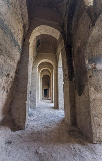
Ana binanın solundaki odalardan biri. Oldukça bakımsız  ve tavanında büyük delikler var. Kilise, binanın sağındadır. Beşik tonozludur içinde karşılıklı nişler ve bir de apsis bulunur. Freskoları doğal etkiler nedeniyle silinmiştir. Kapı üstünde haç ve nişlerin ayıran sütunların arasında çeşitli dini motifler yer almaktadır. Manastırın ortasında tek tonozlu, tandır çukurları ve bir mezar çukuru olan büyük bir oda bulunur. Bu odanın arka tarafında dar ve kıvrımlı bir koridorla geçilen penceresiz, dikdörtgen bir oda vardır. Ortadaki büyük oda. Dip kısmında bir mezar çukuru ve  solda dar bir koridor bulunur. Orta odadan geçilen penceresiz bölüm... Buraya ulaşan dehliz çok dardır ve bir taş kapıyla korunmuştur. Bu gizli odanın zindan, sığınak, kiler vb işlevlerini gördüğü düşünülmektedir. 4. YY ve Erken Bizans dönemine tarihlenen Manastırda kadın ve erkekler ayrı ayrı din eğitimi almaktaydı. Kilise dışında, hamam, gözetleme kulesi, mutfak, yemekhane ve bir kutsal su kaynağı (ayazma) içeren bir külliyeydi.


 Belha Monastery, Belha Monastery, founded by the first Christians who escaped from the persecution of Rome and came to the region in the 4th century, contains the girl and boy watchtower, dungeon, kitchen, Roman bath, dining hall and Ayazma water believed to be holy by Christians.

One of the rooms to the left of the main building. It is quite neglected and has large holes in its ceiling. The church is to the right of the building.
The cradle is vaulted and there are niches in the vault and an apse. Their frescos have been erased due to natural effects. Various religious motifs are located between the columns separating the cross and niches on the door.
In the middle of the monastery is a large room with a single vault, tandoor pits and a burial pit. At the back of this room, there is a rectangular room without windows, which is passed through a narrow curved corridor. Big room in the middle. There is a grave pit at the bottom and a narrow corridor on the left. The windowless section through the middle ... The corridor reaching here is very narrow and protected by a stone door. Imagine that this secret room functions like dungeons, shelters, cellars, etc. Dating to the 4th century and the early Byzantine period, the monastery had separate religious education for women and men. Outside the church, it was a complex with a bath, watchtower, kitchen, dining hall, and a source of holy water (Ayazma).




4 Haziran 2020 Perşembe

Kapıkaya Harabesi - Isparta

Kentin adı bilinen fakat tespit edilemeyen Sandallion, Minassos, Tityassos gibi kentlerden birisi olduğu düşünülmektedir. Şehir Hellenistik dönemde kurulmuştur. Eğimli arazide yer alan kentin güney tarafı surla çevrili, kuzey tarafında ise yüksek bir kayalık bulunmaktadır. Kente girişte iki yandaki kayalara Sagalassos’da olduğu gibi nişler oyularak ostotekler (külkabı) yapılmıştır. Kentin doğu ve batı yamacında teraslar oluşturularak yapılar yerleştirilmiştir. Güneydeki geniş düzlükte 5 sıra oturma basamaklı at nalı biçimli toplantı alanı, doğusunda işlevi belli olmayan kentin en büyük binası bulunur. Tapınak olabilecek bir yapı ve haç planlı bir şapel yer alır. Kentte lahit mezar ve kapak üzerine mezar sahibinin işlendiği iki adet lahit kapağı ve heykeller yer almaktadır. Heykeller Isparta müzesine nakledilmiştir. Kentin güneybatısında antik basamaklarla ulaşılan doğal bir mağara bulunur. Mağara muhtemelen bir kutsal alan olmalıdır.
--------------

The city is thought to be one of the cities with known but undetectable cities such as Sandallion, Minassos, Tityassos. The city was founded in the Hellenistic period. The south side of the city, which is located on the sloping land, is surrounded by a city wall, and on the north side there is a high rocky area. At the entrance to the city, as in Sagalassos, ostoteks were made on the rocks on both sides by carving niches. On the east and west slope of the city, terraces were created and structures were placed. Horseshoe-shaped meeting area with 5 rows of seating steps on the wide plain in the south, and the largest building of the city with no function in the east. There is a structure that can be a temple and a chapel with a crucifix plan. In the city, there are sarcophagus and two sarcophagus lids and sculptures on which the grave owner is engraved. The sculptures were transferred to the Isparta museum. In the southwest of the city, there is a natural cave reached by ancient steps. The cave should probably be a sanctuary.


Ariassos - Antalya

Pisidia Bölgesi kentlerinden olan Ariassos, Antalya’nın 50 kilometre kuzeyinde Antalya kıyısını  Anadolu Patosu'na bağlayan boğaz olan 924 metre yükseklikteki Çubukbeli’nin batısında, Akkoç Köyü'ne 1 kmilometre mesafede bulunmaktadır. Kentin resmi kuruluş yılı Manlius Vulso’nun seferi ve Apameia Barışı’yla bağlantılı olarak M.Ö. 189/188 yılıdır. Kent M.Ö. I. yüzyıldan Gallienus Dönemi’ne (253-267) kadar sikke basımına devam etmiştir. Hierokles tarafından kent, Geç Antik Dönem’de Pamphylia Eyaleti'nde gösterilmektedir. 12'nci yüzyıla kadar Notitia Episcopatum’da Pamphylia II Bölgesi’nin piskoposluğu olarak adlandırılmaktadır.

Diğer Pisidya kentleri ile birlik içerisinde olan Ariassos, Roma Dönemi’nde yollarının inşa edildiği bir geçit olarak yer almaktaydı.Bizans Dönemi'nden sonra kentte yaşam sona ermiştir. Ariassos kent planı incelendiğinde, doğudan batıya doğru ilk önce bir nekropol alanı, şehir surlarının güney köşesi ve sivil yapılar, şehir kapısı, kapıdan batıya doğru uzanan olası bir sütunlu cadde, bu caddenin kuzey tarafında esas kent yerleşimi, batısında yine bir nekropol alanı yer almaktadır. Kent doğu-batı doğrultusunda uzanan bu caddeye paralel olarak kuzey yamaçta oluşturulan teraslar üzerine yerleştirilmiştir. En önemli yapıları hemen hemen tam olarak ayakta duran şehir kapısı, mozole tipi mezar yapıları, şehir surları, Roma Yolu, suyolu, Nymphaion, Bouleuterion, oldukça yıkılmış bir bölümü kaybolmuş Gymnasion, hamam ve tiyatro yapılarıdır. Ariassos Kenti'ne girilen vadinin başlangıcında kentin en görkemli kalıntısı olan anıtsal giriş kapısı yükselir. Üç kemerli şehir kapısının Severus Alexander zamanında kullanılmakta olduğu anlaşılmaktadır. Ayrıca şehir kapısı ile çeşme binası arasında var olduğu kabul edilen sütunlu cadde üzerinde iki, kentin kuzeybatı bölümünde ise bir adet olmak üzere üç adet küçük kilise binası tespit edilmiştir. Kentin batı yamacında bugünkü Akkoç Köyü yolunu keserek inen Antik Roma Yolu kalıntısı mevcuttur. Düzgün döşenmiş iri bloklarla yapılmıştır. Bu yol, Termessos tarafından Ariassos’un batı kapısına gelen yoldur. Ariassos’un şehir kapısından sonra en göz alıcı yapıları anıtsal mezarlardır. Şehir yerleşimi ile bütünleşmiş olarak doğu ve batı tarafta iki nekropol alanı bulunmaktadır. Batı nekropolünün kuzey tarafında 9 tane mozole tipi mezar bulunmaktadır. Bunlar iki krepisli stylobat üzerine oturmuş ortostatlı bir podyum üzerine çift tonoz örtülüdür. Anteler arasındaki 6 merdivenle lahitin bulunduğu odalara çıkılır. Batı nekropolünde dörtgen planlı bir veya iki basamaklı platform üzerine oturmuş doğrudan girişli kırk adet daha basit yapılı mezar binası daha tespit edilmiştir. Doğu nekropolünde ise dokuz adet mezar yapısı karşımıza çıkar. Bunların dışında kireç taşından yapılmış, yanları tabula ansatalı, dar yüzleri Pisidia tipi kalkanlı lahitler ve doğrudan kayaya oyulmuş basit gömü şekilleri de kullanılmıştır.


Pisidia Area Ariassos within the city, 50 kilometers north of Antalya coast of Antalya, the  Anatolia Patou 's 924 meters in height, which connects the throat Çubuk Passage to the west, 1 kmilometr Akkoç from the village. In connection with the expedition of the city's official foundation year  Manlius Vulso and Apameia Peace I BC. It is the year 189/188. Kent BC He continued to print coins from the 1st century to the Gallienus Period (253-267). Hierokles city by the Late Antiquity from Pamphylia State 'is to be shown. Until the 12th century Notitia to my episcopate atIt is called the diocese of Pamphylia II Region .
Together with other Pisidian cities, Ariassos was located as a gateway where roads were built during the Roman Period . Life ended in the city after the Byzantine Period . When the Ariassos city plan is analyzed, first a necropolis area from the east to the west, the south corner of the city walls and civil buildings, the city gate, a possible columnar street extending from the gate to the west, the main city settlement on the north side of this street, and a necropolis area to the west. The city was placed on terraces formed on the north slope in parallel with this street extending in the east-west direction. The most important structures are almost completely standing city gate, mausoleum-type tomb structures, city walls, Roman Road, waterway, Nymphaion, Bouleuterion, Gymnasion, baths and theater structures, which have been destroyed in a rather destroyed part. The monumental entrance gate, the most magnificent remnant of the city, rises at the beginning of the valley, which is entered into the city of Ariassos. It is understood that the three-arched city gate was used during the time of Severus Alexander . In addition, three small church buildings were identified on the street with columns, which is accepted to exist between the city gate and the fountain building, and one in the northwestern part of the city. On the western slope of the city, there is the ruins of the Ancient Roman Road, which descends by cutting the road of Akkoç Village today . It was built with large blocks that were properly laid. This road is the road to the west gate of Ariassos by Termessos. The most spectacular buildings of Ariassos after the city gate are monumental tombs. Integrated with the city settlement, there are two necropolis areas on the east and west sides. There are 9 mausoleum-type tombs on the north side of the western necropolis. These are covered with double vaults on an orthostated podium seated on two crepe stylobats. You can go to the rooms where the sarcophagus is located by 6 stairs between the anteles. In the western necropolis, 40 more simple grave buildings with direct access were found, sitting on a one or two-step platform with a rectangular plan. In the eastern necropolis, we see nine grave structures. Apart from these, the sarcophagus made of limestone, the sides are made of tabular enamels, the narrow faces of the Pisidia-type shields and simple burials carved directly into the rock are used. 


3 Haziran 2020 Çarşamba

Olba - Mersin

Hellenistik Dönem’de Olba Krallığı’nın merkezi ve önemli bir ticaret şehridir. Olba aynı zamanda önemli bir dinsel merkez olmuştur. Özellikle Hıristiyanlık döneminde bu durum yazılı kaynaklar dışında dinsel mimari kalıntılarda da kendini göstermektedir. Bunlar Olba akropolisinin batısında bulunan büyük kilise kalıntısı, akropolis üzerinde yer alan bir çok küçük kilise kalıntıları ve su kemerinin bulunduğu akropolisin doğusundaki vadide geniş bir alana yayılan manastır kalıntıları sayılabilir. Olba piskoposluk merkezi olarak Erken Hıristiyanlık döneminde önemini sürdürmüştür. Bu dönemde Olba ve hemen yakınındaki Diokaesareia ayrı ayrı piskoposluk merkezleri olmuşlardır. Olba piskoposluğuda, Isauria’nın başpiskoposluk merkezi olan Seleukeia’nın alt birimi olarak diğer Isauria ve Kilikia piskoposlukları Diocaesereia, Kelenderis, Claudiopolis ile öteki piskoposluklar gibi 10. yüzyılın başından 7. yüzyıla kadar Antiokheia patrikhanesine bağlı olmuştur. Olba’da bulunan, Septimus Severus zamanında yaptırılmış olan çeşme binasının yanı sıra diğer bir önemli eser ise nekropolün bulunduğu vadi üzerinde kurulmuş, 150 m. uzunluğunda, 25 m. yüksekliğindeki iki katlı su kemeridir. Bu su kemerinin korunması ve çevrenin gözetlenmesi için kuleler inşa edilmiş olması yapının önemini göstermektedir. İ.S. 199 Septimus Severus dönemine tarihlenen su kemerinin üzerindeki yazıtta “Olbalılar’ın Kenti” yazmaktadır. Antik çeşme ile aynı dönemde yapılmış olan bu kemerler Bizans İmparatoru II. Iustin yönetimi sırasında (566) onarım görmüştür. Çeşmenin yanında bulunan tiyatro binasından bazı oturma basamakları ile sahnenin bir bölümü günümüze dek kalmıştır. Nekropol alanında ise farklı mezar tipleri yer almaktadır. Bir tepenin üzerinde kurulmuş bulunan antik şehirdeki diğer kalıntılar arasında evlerde bulunmaktadır. Helenistik, Roma ve Erken Bizans Dönemleri’nde iskan görmüştür.


It is the center and an important commercial city of the Olba Kingdom in the Hellenistic Period. Olba has also been an important religious center. Especially in the Christian period, this situation shows itself in religious architectural remains apart from written sources. These include the large church ruins to the west of the Olba acropolis, many small church ruins on the acropolis, and the monastery ruins spread over a wide area in the valley to the east of the acropolis, where the aqueduct is located. Olba continued its importance as the episcopal center in the Early Christian period. In this period, Olba and Diokaesareia in the immediate vicinity became separate episcopal centers. As the sub-unit of Seleukeia, the episcopal center of Isauria, Olba was linked to the Patriarchate of Antiokheia from the beginning of the 10th century to the 7th century, such as Diocaesereia, Kelenderis, Claudiopolis and other dioceses. In addition to the fountain building in Olba, which was built during the time of Septimus Severus, another important work was established on the valley where the necropolis is located, 150 m. long, 25 m. It is a two-storey aqueduct. The fact that towers were built to protect this aqueduct and to watch the environment shows the importance of the building. BUSINESS. The inscription on the aqueduct, dated to the Septimus Severus era, writes "The City of the Olbalılar". These arches were built in the same period as the ancient fountain, Byzantine Emperor II. It was repaired during the Iustin administration (566). A part of the stage has remained until today with some sitting steps from the theater building next to the fountain. There are different types of graves in the necropolis area. Among the other ruins in the ancient city, built on a hill, are among the houses. It was inhabited during the Hellenistic, Roman and Early Byzantine Periods.